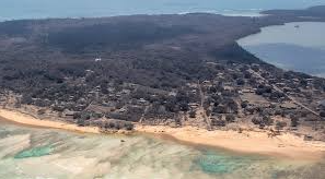
New Zealand surveillance flight reveals devastating damage across the islands following the eruption and tsunami.
New images have emerged from Tonga’s volcano and tsunami-hit islands after a New Zealand Defence Force surveillance flight returned from the affected region. The aerial photographs show severe damage to the islands, with land and trees completely coated in ash. The eruption of the massive undersea volcano, followed by a tsunami, struck the Pacific nation on Saturday, leading to at least three confirmed deaths.
The aerial views, particularly from Nomuka, a small island in the southern Haʻapai group, illustrate the extent of destruction caused by the natural disaster. The country remains largely cut off, with limited access to the hardest-hit areas.